YVY
YVY uses satellite data, climate information, and AI to optimize fertilizer application, helping farmers reduce waste, increase yields, and make smarter agricultural decisions. 🌾🛰️📈
- 0 Raised
- 479 Views
- 0 Judges
Categories
Gallery


Description
THE CHALLENGE OF INEFFICIENT FERTILIZATION
Modern agriculture faces a growing challenge: producing more food while using fewer resources and minimizing environmental impact. Today, fertilizers represent a global market worth more than US$230 billion annually and are essential to global food security. However, a significant portion of these inputs is still applied uniformly across fields, without considering the specific nutritional needs of different areas within a crop.
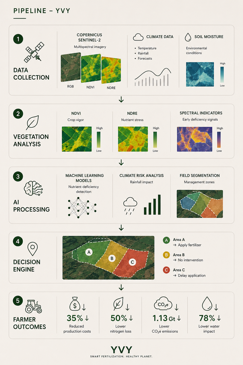
As a result, up to 50% of applied nitrogen can be lost to the environment through leaching, volatilization, or surface runoff. Beyond increasing production costs for farmers, these losses contribute to approximately 1.13 gigatons of CO₂ equivalent emissions per year and are associated with nearly 78% of global freshwater eutrophication processes.
At the same time, extreme weather events, changing precipitation patterns, and increasing climate variability make it increasingly difficult to determine when, where, and how much fertilizer should be applied. In this context, farmers, cooperatives, and agribusinesses need tools capable of transforming complex environmental data into precise agronomic decisions.
OUR SOLUTION
YVY is an intelligent precision fertilization platform powered by Earth Observation and Artificial Intelligence. Our solution transforms satellite, climate, and environmental data into actionable recommendations that help farmers apply the right nutrients, in the right place, at the right time.
The platform integrates Copernicus Sentinel-2 imagery, climate information, soil moisture data, and advanced spectral indices to continuously monitor crop health. Through Artificial Intelligence models, YVY identifies early signs of plant stress and potential nutrient deficiencies before they become visible to the naked eye, enabling more efficient fertilizer management.
Key features include:
Continuous Satellite Monitoring: Uses Sentinel-2 imagery with 10-meter spatial resolution and frequent revisit cycles to track crop development in near real time.
Vegetation and Nutrient Stress Analysis: Leverages spectral indices such as NDVI and NDRE to detect variations in crop vigor, potential nutrient deficiencies, and low-performance areas.
Intelligent Recommendation Engine: Combines satellite, climatic, and agronomic information to generate location-specific recommendations, optimizing fertilizer application across the field.
Climate Risk Assessment: Integrates weather forecasts to identify conditions that may affect nutrient uptake or increase losses caused by heavy rainfall events.
Interactive Decision-Support Maps: Provides intuitive visualizations that allow farmers, cooperatives, and agribusinesses to quickly identify priority intervention zones.
Initially designed for Latin America, YVY has strong global scalability potential, contributing to a more efficient, profitable, and sustainable agricultural sector.
DIFFERENTIATION
Unlike traditional agricultural monitoring tools that focus primarily on displaying satellite imagery or vegetation indices, YVY transforms data into actionable decisions. Our platform not only identifies where a potential problem exists, but also recommends when to act, where to intervene, and how to optimize fertilizer use by considering both agronomic and climatic factors.
YVY combines high-resolution Sentinel-2 imagery, advanced spectral indices, climate information, and Artificial Intelligence into a single platform capable of continuously monitoring crop health and generating field-specific recommendations.
While many existing solutions focus exclusively on monitoring or are designed primarily for large-scale farms, YVY was built to serve farmers, cooperatives, agribusinesses, and financial institutions alike, democratizing access to precision agriculture technologies.
This ability to transform complex data into practical actions helps reduce costs, increase productivity, and minimize environmental impacts, positioning YVY as a proactive tool for the future of agriculture.
Rather than simply showing what is happening in the field, YVY helps producers anticipate problems, optimize resources, and make smarter decisions. This combination of continuous monitoring, predictive analytics, and actionable recommendations makes the platform a strategic ally for improving global food security, reducing waste, and promoting a more sustainable agricultural future.
WHO WE ARE?
YVY was developed by a multidisciplinary team of students and professionals from Data Science, Computer Science, and Marketing, united by the goal of making agriculture more efficient, sustainable, and data-driven. Our expertise combines Earth Observation, Artificial Intelligence, data analytics, software development, and strategic communication.
Geovanna Lim – Data Science Student, Virtual University of the State of São Paulo (UNIVESP)
Founder of YVY and responsible for the project's data strategy, Earth Observation integration, and AI-driven recommendation framework. Passionate about Artificial Intelligence, sustainability, and geospatial technologies, she has experience in data analytics, machine learning, automation, and innovation projects. Geovanna is also the founder of CO2.IA, a climate intelligence startup focused on carbon management and environmental impact solutions.
Luis Hoi – Computer Science Student, University of Guelph
Responsible for the platform architecture, software development, and technical implementation. His experience includes web development, machine learning applications, data analysis, and technology-driven problem solving. Luis has developed digital solutions in education, accessibility, and AI-powered systems, while also contributing to technology communities and innovation initiatives.
Miguel Ignacio – Advertising Professional
Responsible for communication, branding, and market positioning. Miguel contributes to the project's user-centered approach, helping translate complex technical concepts into accessible solutions for farmers, cooperatives, and agribusiness stakeholders. His expertise supports the development of a scalable and market-oriented product strategy.
DATA SOURCES USED
YVY combines multiple Earth Observation and environmental datasets to generate intelligent fertilization recommendations:
Copernicus Sentinel-2
High-resolution multispectral imagery used to monitor crop development, vegetation vigor, and nutrient-related stress indicators.
Spectral Vegetation Indices (NDVI, NDRE)
Derived from Sentinel-2 imagery to assess plant health, detect nutritional deficiencies, and identify spatial variability within agricultural fields.
Climate and Weather Data
Meteorological variables including temperature, precipitation, and weather forecasts used to evaluate climate risks and optimize fertilizer application timing.
Soil Moisture Data
Environmental datasets used to assess field conditions and improve recommendation accuracy.
Artificial Intelligence Models
Machine learning algorithms designed to analyze satellite and environmental data, identify nutrient-related stress patterns, estimate agronomic risks, and generate location-specific recommendations.
By combining Earth Observation, climate intelligence, and Artificial Intelligence, YVY transforms complex environmental information into practical decisions that help farmers increase productivity while reducing costs and environmental impact.
PRODUCTS
YVY provides intelligent monitoring, analysis, and decision-support tools designed to make fertilizer management more precise, efficient, and sustainable.
Satellite Monitoring Dashboard
Provides near real-time visualization of crop conditions through Sentinel-2 imagery, vegetation indices, climate information, and soil moisture data. Farmers and agronomists can quickly identify areas showing signs of nutrient stress, productivity decline, or abnormal crop development.
Nutrient Stress Detection
Uses advanced spectral indices such as NDVI and NDRE combined with Artificial Intelligence models to identify potential nutrient deficiencies before visible symptoms appear in the field. This enables early intervention and more efficient resource allocation.
Intelligent Fertilization Recommendations
Generates location-specific recommendations based on satellite observations, climate conditions, and crop performance indicators. The platform helps determine where, when, and how fertilizer applications should be optimized to maximize efficiency and reduce waste.
Climate Risk Assessment
Analyzes weather forecasts, precipitation patterns, and environmental conditions that may influence nutrient uptake or fertilizer losses. This allows producers to avoid applications during unfavorable conditions and improve decision-making.
Interactive Field Maps
Provides intuitive maps highlighting priority intervention zones, crop performance variability, and recommended management actions. These visualizations help transform complex environmental data into actionable insights for farmers and agribusinesses.
PROJECTED RESULTS: WHAT IMPACT CAN YVY DELIVER?
To evaluate the potential impact of YVY, we analyzed expected outcomes based on precision agriculture research, satellite-driven nutrient management practices, and AI-supported fertilization strategies.
Conventional Management
Fertilizers are applied uniformly across the field without considering crop variability, nutrient demand, or environmental conditions.
Data-Informed Management
Producers use satellite imagery, vegetation indices, climate information, and environmental data to support fertilization decisions.
YVY-Assisted Management
Farmers follow YVY's AI-powered recommendations, combining Earth Observation, climate intelligence, and nutrient stress analysis to optimize fertilizer applications.
Result 1: Crop Productivity
Based on published precision agriculture studies and fertilizer optimization practices, YVY estimates an average yield increase of up to 23% compared to conventional fertilization approaches.
Earlier nutrient stress detection and more targeted interventions help crops receive the nutrients they need when and where they are needed most.
Result 2: Fertilizer Efficiency
YVY estimates a reduction of up to 18% in fertilizer use by helping producers avoid unnecessary applications and prioritize areas that truly require intervention.
Less waste means lower operational costs and more efficient use of agricultural inputs.
Result 3: Farm Profitability
By combining improved productivity with more efficient fertilizer use, YVY estimates a potential increase of up to 31% in profit per hectare.
Better decisions lead to better resource allocation and stronger economic performance.
Result 4: Environmental Impact
Precision nutrient management can significantly reduce nutrient losses to the environment.
Based on existing research and optimization practices, YVY estimates reductions of up to 42% in nutrient leaching, helping decrease environmental impacts on soils and water resources.
WHAT DOES THIS MEAN?
YVY helps farmers make smarter fertilization decisions.
Rather than applying fertilizers uniformly across an entire field, producers can identify where intervention is needed, when nutrients should be applied, and how resources can be used more efficiently.
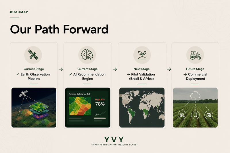
These indicators represent projected outcomes based on scientific literature and precision agriculture practices. Field validation and pilot testing are currently in progress.
YVY is currently in discussions with agricultural producers in Brazil and Africa regarding future pilot deployments, enabling the platform to be tested across diverse climatic and operational conditions. These pilot opportunities will support the validation of the platform across different agricultural environments and production systems.
YVY does more than generate maps and analytics—it transforms satellite data into actionable decisions that improve productivity, profitability, and sustainability.
By combining Earth Observation, climate intelligence, and Artificial Intelligence, YVY aims to contribute to a more efficient agricultural sector, stronger food security, and a more sustainable future for farming worldwide.
USERS AND MEMBERSHIPS
YVY serves multiple stakeholders across the agricultural value chain, each benefiting from specialized tools and insights.
Farmers
Use YVY to optimize fertilizer applications, reduce production costs, improve yields, and make data-driven decisions throughout the growing season.
Cooperatives
Monitor multiple farms simultaneously, support member producers with agronomic recommendations, and improve resource allocation across larger agricultural regions.
Agribusiness Companies
Leverage advanced analytics, large-scale monitoring, and decision-support tools to improve operational efficiency, sustainability performance, and productivity.
Financial Institutions
Access agricultural intelligence and risk indicators that support lending decisions, sustainability programs, and agricultural financing initiatives.
Researchers and Agricultural Organizations
Use YVY's environmental and agronomic insights to study crop performance, nutrient management strategies, and sustainable agricultural practices.
YVY Membership Plans
Starter
Access to crop monitoring, vegetation indices, basic field maps, and environmental alerts.
Ideal for individual farmers looking to improve fertilizer efficiency and crop management.
Professional
Includes advanced analytics, AI-powered recommendations, climate risk assessment, and cooperative-level monitoring capabilities.
Designed for cooperatives, consultants, and medium-sized agricultural operations.
Enterprise
Provides multi-farm management, advanced dashboards, API integrations, custom analytics, and dedicated technical support.
Designed for agribusiness companies, financial institutions, governments, and large-scale agricultural organizations.
Research & Innovation
Offers access to historical datasets, environmental indicators, API services, and advanced analytical tools.
Designed for universities, research institutions, startups, and innovation programs focused on sustainable agriculture.
PIPELINE
BUSINESS MODEL
1. Strategic Partners
Copernicus Programme
Principal source of Earth Observation data, providing Sentinel-2 imagery used for crop monitoring, vegetation analysis and agricultural intelligence.
European Space Agency (ESA)
Supports the Sentinel mission ecosystem and promotes innovation through Earth Observation technologies and satellite applications.
Embrapa
Brazil’s leading agricultural research institution, with more than 40 research centers focused on innovation, productivity and sustainability in agriculture.
Inter-American Institute for Cooperation on Agriculture (IICA)
International organization operating in 34 countries across the Americas, supporting agricultural innovation, food security and rural development.
BYD
Global leader in sustainable technologies and electrification, contributing to the advancement of green innovation and sustainable development initiatives.
2. Key Activities
Satellite Data Collection and Processing
Acquisition and processing of Sentinel-2 imagery, weather information, soil moisture, temperature and precipitation data.
Spectral Analysis
Calculation of NDVI, NDRE and other vegetation indices to detect crop vigor and early nutrient stress.
Artificial Intelligence Development
Training AI models capable of identifying nutrient deficiencies, predicting environmental risks and optimizing fertilizer applications.
Platform Maintenance and Continuous Improvement
Continuous enhancement of algorithms, dashboards and recommendation systems to ensure accuracy and scalability.
3. Value Proposition
Reduce Fertilizer Waste
Optimize fertilizer use through data-driven recommendations and precision agriculture techniques.
Icrease Productivity
Identify nutritional issues before they become visible, enabling faster and more effective interventions.
Climate-Aware Decisions
Integrate satellite and weather data to recommend the best timing for fertilizer applications.
Sustainable Agriculture
Reduce environmental impacts associated with nutrient losses, greenhouse gas emissions and water contamination.
4. Customer Relationships
Self-Service SaaS Platform
Intuitive dashboards and interactive maps that simplify agricultural decision-making.
Technical Support
Guidance and assistance for farmers, cooperatives and agribusiness organizations.
Continuous Monitoring
Frequent updates based on new satellite imagery and weather forecasts.
Automated Reports
Actionable insights and recommendations delivered through data-driven reports.
5. Customer Segments
Small Farmers
More than 500 million smallholder farms operate worldwide, representing a significant opportunity for accessible precision agriculture solutions.
Agricultural Cooperatives
Brazil has more than 1,100 agricultural cooperatives, responsible for a substantial share of national agricultural production.
Agribusiness Companies
Agribusiness represents approximately 24% of Brazil’s GDP, highlighting the sector’s economic importance.
Financial Institutions
Brazil’s 2025/2026 Rural Credit Plan allocated more than R$516 billion to support agricultural financing and development.
6. Cost Structure & Revenue Streams
Operating Costs
CategoryMonthly Cost
| Cloud Infrastructure + AI + Database | US$ 500 |
| Marketing (Google, LinkedIn, Events) | US$ 500 |
| Tools (Figma, Notion, GitHub, Lovable, Canva, Domain, etc.) | US$ 300 |
| Administrative / Legal / Accounting | US$ 300 |
| Coworking / Office Infrastructure | US$ 500 |
| Operational Reserve | US$ 400 |
| Operating Subtotal | US$ 2,500 |
Team
RoleMonthly Cost
| CEO | US$ 1,500 |
| CTO | US$ 1,500 |
| CMO | US$ 1,500 |
| Agronomic Consulting | US$ 1,000 |
| Payroll Taxes & External Services | US$ 500 |
| Team Subtotal | US$ 6,000 |
Total Operating Expenses (OPEX)
US$ 8,500/month
Revenue Streams
Starter Plan: US$ 100/month
Designed for small farmers and small-scale agricultural operations.
Professional Plan: US$ 500–5,000/month*
Designed for agricultural cooperatives, agronomic consulting firms, and medium-sized producers.
Enterprise Plan: US$ 5,000–20,000/month*
Designed for large agricultural groups, financial institutions, insurance companies, and government organizations.
White Label Licensing
Platform licensing for cooperatives, agribusiness companies, and organizations wishing to operate the solution under their own brand identity.
Custom Analytics
Development of tailored analyses, dashboards, and specialized studies for financial institutions, insurance companies, and agribusiness organizations.
Financial Institution Solutions
Provision of agricultural and climate intelligence indicators to support risk assessment, rural credit underwriting, and agricultural portfolio monitoring.
*Professional and Enterprise pricing varies according to the monitored area (hectares), operational complexity, and selected analytical modules.
BREAK-EVEN ANALYSIS
Fixed Costs
US$ 102K/year
Average Annual Revenue per Customer
US$ 33K/year
(Based on the Professional Plan average ticket of US$ 2,750/month.)
Variable Cost per Customer
US$ 1.2K/year
(Cloud infrastructure, AI processing, data storage, and operational support.)
Contribution Margin
US$ 31.8K/year
(Average annual revenue per customer after variable costs.)
Break-Even Point
4 CLIENTS
YVY reaches operational break-even with approximately four Professional Plan customers.
Scalability
10 CLIENTS
The operation becomes highly profitable, generating strong recurring revenue while maintaining a relatively lean cost structure.
Note
The break-even analysis was calculated using a conservative scenario, considering estimated annual operating expenses of approximately US$102,000 and the average Professional Plan ticket (US$2,750/month), based on the midpoint of the proposed pricing range (US$500–5,000/month).
Additional revenue sources such as White Label Licensing, Custom Analytics, and Financial Institution Solutions were intentionally excluded from this projection, making the estimate conservative and providing additional upside potential for future growth.
7. Environmental & Social Impact
35%
Fertilizers can represent up to 35% of agricultural production costs.
50%
Less than 50% of applied nitrogen is effectively absorbed by crops.
1.13 Gt CO₂e
Annual greenhouse gas emissions associated with synthetic nitrogen fertilizers.
78%
Share of global freshwater and coastal eutrophication linked to food production systems.
By improving fertilizer efficiency, YVY helps reduce costs, increase productivity and promote more sustainable agricultural practices.
8. Financial Sustainability
Precision Agriculture Market
Estimated at more than US$12.8 billion in 2024, with projections exceeding US$30 billion by 2030.
Global Fertilizer Market
Valued at more than US$230 billion annually.
Earth Observation Market
Expected to surpass US$700 billion globally by 2030.
Scalable SaaS Model
Recurring subscription revenue combined with global satellite coverage enables expansion across Latin America and international markets.
Conclusions
Unlike traditional agricultural monitoring solutions that focus primarily on displaying satellite imagery and vegetation indices, YVY transforms Earth Observation data into actionable fertilization decisions. By combining satellite intelligence, climate analysis, and Artificial Intelligence, the platform helps farmers determine where, when, and how nutrients should be applied more efficiently.
Agricultural Impact: YVY supports farmers, cooperatives, agribusinesses, and financial institutions with tools that improve productivity, optimize fertilizer use, and promote more sustainable farming practices.
Technical Intelligence: Advanced analysis of Sentinel-2 imagery, vegetation indices such as NDVI and NDRE, climate information, and machine learning models enables early detection of nutrient stress and more informed decision-making.
Scalability: Initially designed for Latin America, YVY can be adapted to agricultural regions worldwide, supporting different crops, climates, and production systems.
Validation Pathway: Through ongoing discussions with agricultural producers in Brazil and Africa, YVY has identified opportunities for future pilot deployments and real-world validation across diverse agricultural environments.
Innovation through Earth Observation: By transforming satellite data into practical recommendations, YVY bridges the gap between space technology and everyday agricultural decision-making.
YVY is more than a monitoring platform, it is a decision intelligence system designed to increase agricultural productivity, reduce waste, strengthen food security, and contribute to a more sustainable future for global agriculture.