AquaBeacon
Disaster Risk Monitoring
- 0 Raised
- 1,795 Views
- 0 Judges
Tags
Categories
Gallery


Description
💎 Idea
AquaBeacon uses Sentinel 1 and 2 data and is a -based water-risk awareness prototype for municipalities and local resilience teams.
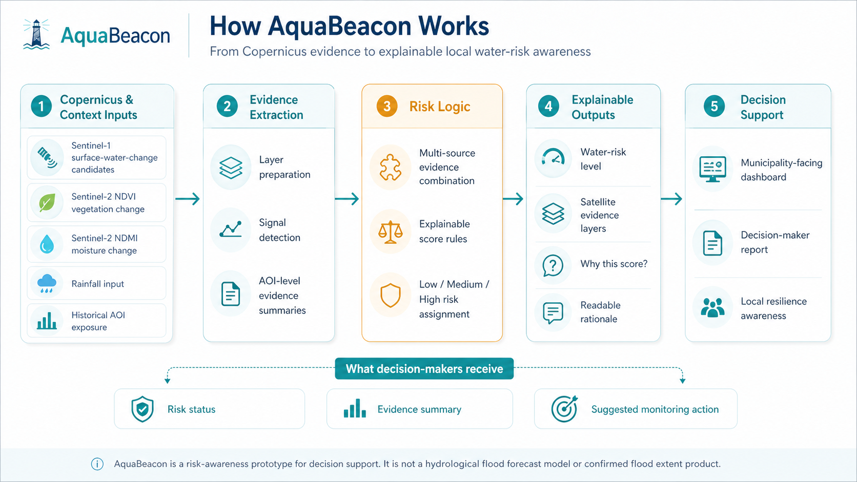
The system turns satellite evidence and environmental triggers into a simple, explainable Low / Medium / High water-risk signal. Instead of showing raw satellite layers only, AquaBeacon helps decision-makers understand what changed, why the risk level was assigned, and what should be checked next.
For the hackathon MVP, AquaBeacon combines:
- Sentinel-1 radar-change evidence for possible surface-water-change candidates
- Sentinel-2 NDVI vegetation-change indicators
- Sentinel-2 NDMI moisture-change indicators
- rainfall input
- historical AOI exposure
- Elevation maps
The output is a dashboard and decision-maker report showing the selected area, risk level, supporting evidence layers and readable reasons behind the Risk score e.g (Low , Medium, High). It also suggests users evacuation plans and route using the Elevation maps.
AquaBeacon is not a hydrological forecast model and does not claim confirmed flood extent. It is an early-awareness and decision-support prototype that helps translate Copernicus data into practical local risk insight.
🛰️ EU Space Technologies
AquaBeacon uses European space technology through the Copernicus programme and Sentinel missions.
The MVP uses Sentinel-1 and Sentinel-2 data accessed through Copernicus/openEO workflows.
Sentinel-1 radar data is used to identify possible surface-water-change candidates by comparing before and after event windows. Sentinel-2 data is used to calculate vegetation and moisture-related indicators, including NDVI and NDMI, to provide environmental context around the selected area.
These satellite-derived layers are combined with rainfall input and historical AOI exposure to generate a transparent water-risk score and explanation.
This allows AquaBeacon to turn Earth observation data into a format that can be understood by municipalities, resilience teams, and other non-specialist decision-makers.
🌍 EU Space for Water
AquaBeacon addresses Challenge #3: Disaster Risk Monitoring.
Water-related risks are becoming harder to manage as communities face floods, drought, changing moisture conditions, and increasing pressure on local resilience systems. Many existing tools provide data, but local decision-makers still need clearer, faster, and more understandable risk awareness.
AquaBeacon supports disaster risk monitoring by combining Copernicus satellite evidence with simple rule-based scoring. The prototype shows how municipalities could receive an explainable water-risk signal for a selected area, supported by satellite evidence layers and a short decision-maker report.
The goal is not to replace official hydrological forecasts or emergency systems. The goal is to provide an additional early-awareness layer that helps local teams interpret satellite evidence more quickly and prepare better.
🤼 Team
Ali Ahmad — Backend / Technical Development / Team Owner
Ali leads project coordination and contributes to backend development, integration, and overall technical delivery.
---
Rizwana — Frontend/ Backend / Product lead / Business strategy
Rizwana contributes to the frontend, backend, product direction, business framing, and user-facing presentation of the solution.
---
János — Data Processing / Sentinel Analysis / Technical Development
János focuses on the Copernicus/openEO data pipeline, Sentinel-1 and Sentinel-2 processing, NDVI/NDMI indicators, risk logic, and technical validation of the MVP.
---
Xiao — Design / Visual Identity
Xiao contributes to the visual identity, presentation design, and user-facing design direction of AquaBeacon.
---
Csilla — Research / Testing / Support
Csilla supports the team through research, testing, coordination, and review of related solutions and project assumptions.