
ENKI
A predictive model for water disaster resilience. We fuse Copernicus data, ML, and bio-hazard tracking to foresee disasters and dynamically route people.
- 0 Raised
- 472 Views
- 0 Judges
Team
Tags
Categories
Gallery


Description
💎 Idea
In a world shaped by climate change, where natural disasters are becoming increasingly severe and destructive (as seen in the floods in Emilia-Romagna and Valencia), we have developed an effective and accessible solution. ENKI is a predictive model that leverages Copernicus data to recalculate routing through the most congested road junctions in major cities and safeguard critical infrastructure -such as power grids and water networks- against environmental hazards.
🛰️ EU space technologies
Here a table with all the informations we used in our idea
| Type of product | Element | Physical Source / Sensor | Technical Function |
| Source (Sensor) | Sentinel-1 (SAR) | Sentinel-1 Satellite (C-Band Radar) | Soil reflectivity (backscatter) at time T0 and baseline history. |
| Altimetric Product | Copernicus GLO-30 | TanDEM-X Satellite (X-Band Radar) | Elevation z (Digital Elevation Model). |
| Thematic Product | CLMS Imperviousness | Sentinel-2 Processing (Optical) | Soil sealing degree (0-100%). |
| Thematic Product | ESA WorldCover | Multi-sensor (S1 + S2) | Categorical land cover classification. |
| Geographic Database | OpenStreetMap (OSM) | Crowdsourcing / Vector | Infrastructure, building, and hydrography geometry. |
| API Service | Open-Meteo | ERA5 / IFS / SMAP | Soil saturation and accumulated rainfall (last 1h and 24h). |
EU Space for Water
We address the Disaster Risk Monitoring challenge. By integrating predictive rerouting and hazard mapping, ENKI helps to safeguard food production, ecosystems, and human livelihoods through proactive adaptation strategies. Our model empowers utility providers -specifically energy and water companies- to reconfigure their networks in real-time, preventing structural damage and ensuring the continuity of essential resource management during extreme hydrogeological events.
🤼 Team
Vittorio Cava – CEO
He coordinates the technical development of the ENKI model, overseeing the integration of neural network architectures with multi-source geospatial data. Vittorio ensures the structural consistency of the 11-channel tensor and the overall project delivery.
As a CEO he also provides his steering task for long-term growth.Lorenzo Gaudino – CTO
He specializes in the implementation of the U-Net deep learning architecture and the algorithmic processing of satellite imagery. Lorenzo is responsible for the core predictive logic that translates radar and altimetric data into hazard maps.Simone Felici – COO
He architected the end-to-end software infrastructure, developing both the interactive mapping system and the dynamic rerouting engine. Simone bridged the gap between predictive backend data and the user interface, ensuring a seamless experience for navigating urban flood hazards.Tommaso Vergine – CFO
He oversees the development of the business model and commercial strategy, focusing on operational resilience for the energy and utility sectors. Tommaso ensures that ENKI’s predictive capabilities are translated into high-value decision-making tools for infrastructure protection.Niccolò Nizza – Head of Sats
Aerospace Engineering graduand at Sapienza University of Rome, he is stuying in detail Guidance, navigation and control for space systems.
As an Aerospace Engineer, he provides expertise in SAR backscatter analysis and satellite orbital mechanics. Niccolò optimizes the interpretation of radar signals to ensure accurate soil moisture and flood detection under all weather conditions.Claudia Gaia Rossberg – Head of Bio
She applies her background in biotechnology to analyze land cover, vegetation friction, and the ecological impact of water management. Claudia ensures the model accurately reflects the biological variables that influence hydraulic runoff and ecosystem preservation.
🏛️ Case Study: RomeWe selected Rome as our primary study site due to its unparalleled urban heterogeneity, characterized by significant topographic variance (the "Seven Hills") and a complex hydrological network.
Why Rome?
Vulnerability: The Lazio region is the second most flood-prone area in Italy, with Rome consistently appearing at the top of national reports for extreme weather incidents.
Strategic Hub: As a dense urban center, it hosts critical headquarters for global utilities (e.g., ACEA, ENEL), making infrastructure protection a high-value economic objective.
Training & Ground Truth: For model training, we utilized official historical reports of street-level flooding as our labels
- The Model: ResU-Net Architecture
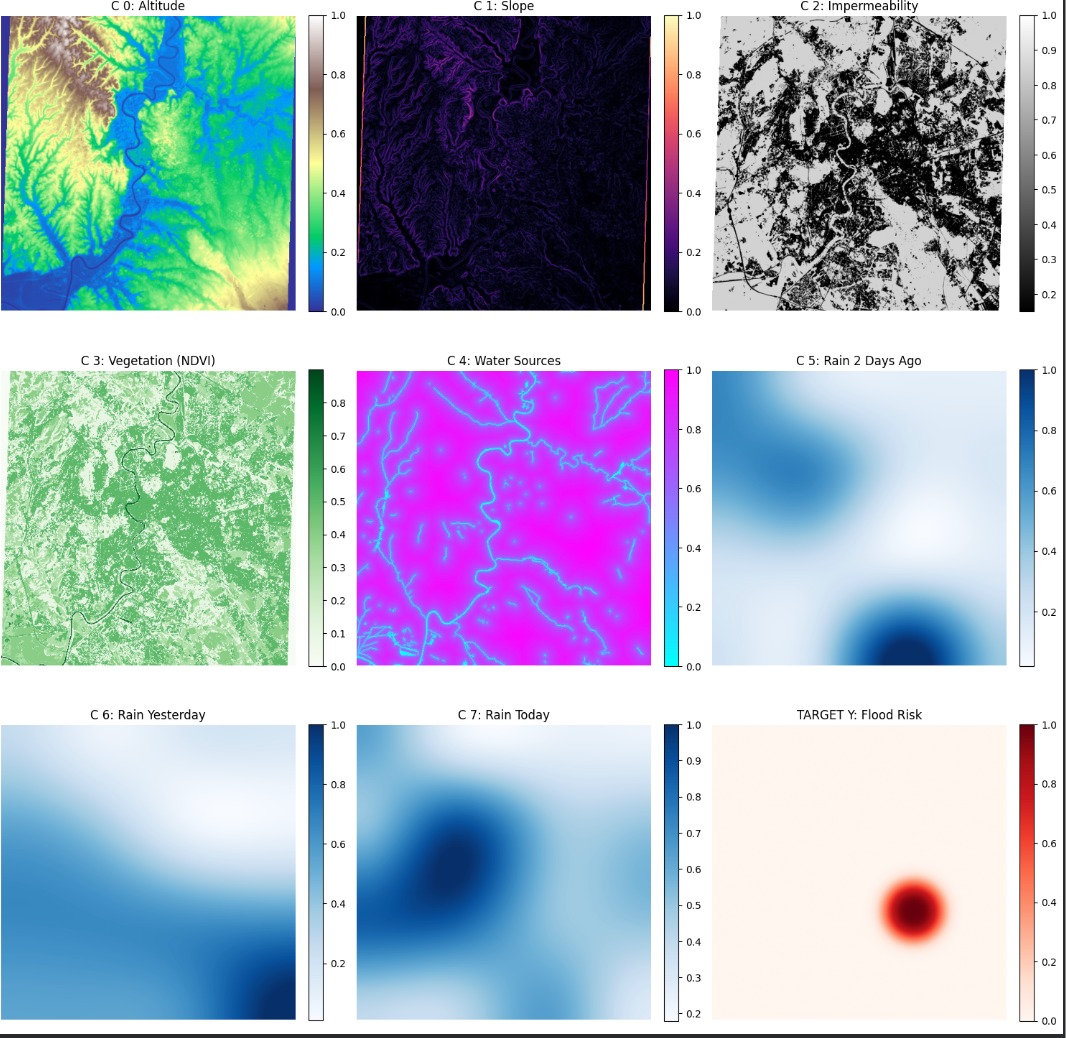
🧠 The Model: ResU-NetENKI utilizes a ResU-Net, a cutting-edge architecture in satellite data analysis that combines multi-source inputs to overcome the limitations of single-sensor monitoring.
- Spatial Context: Unlike standard models, the ResU-Net prioritizes neighboring pixels, ensuring predicted flood zones are spatially coherent and follow the physical city layout.
- Residual Learning: Residual blocks allow the network to "learn by subtraction," effectively filtering out the "noise" inherent in radar signals while capturing fine urban details.
Input Tensor:Altitude: Elevation data from the GLO-30 DEM.
Slope: Calculated gradient to identify natural accumulation basins.
Impermeability: Soil sealing data to calculate runoff speed.
Vegetation (NDVI): Derived from Sentinel-2 to assess biological drainage capacity.
Water Sources: Proximity to the Tiber and Aniene rivers.
Rain history