𓆤 WASP - Water Analysis Satellite Program 𓆤
The only swarm needed to protect our ecosystem from pollution and oil spills
- 0 Raised
- 395 Views
- 0 Judges
Tags
Categories
Gallery




Description
The problem
The Water has no voice.
Every year, many things that no one is aware of happen: oil tankers that wash their tanks offshore, away from the eyes of the law, or hidden waste disposal in rivers, or pollutants that poison the flora and wash it ashore, or unchecked algae blooms, or waterborne diseases that fester in contaminated waters, or the depletion of fishing grounds due to pollution and diseases. Keeping track of everything is slow, and reliant on patrols of the Coast Guard, Navy or aerial surveys. And no one can be everywhere.
Our solution
WASP is born to answer one simple question: how can we see water pollution everywhere, at every hour, comes sun or torrential rains, day and night, without breaking the bank?
Our answer comes in three parts: data from EU satellite constellations, small IoT buoys that study water quality and a platform that gathers everything, analyses the data and tips off whom it may concern, all bundled up in a digital twin that can predict where the pollution might go in a 48 hours period using smart telemetries and predictive models.
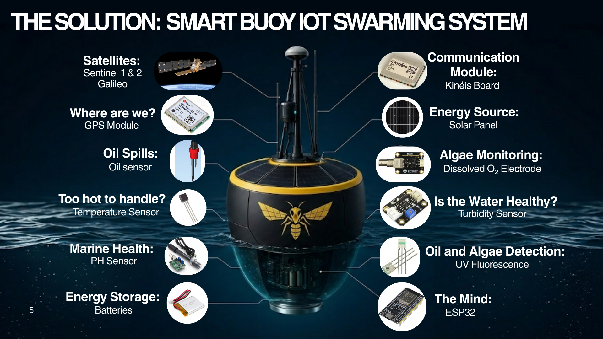
Our buoys are built keeping in mind cost efficiency. All the components are essential and budget friendly. The swarm of buoys is built following IoT networking protocols, that allow the communication module on board to 'go to sleep' and 'wake up' just to transmit data to save power. A central node handles processing and data transfer between the buoys and the digital twin.
Here's all the components:
- Main computing unit: ESP32-WROOM-32
- Communication module: Kinèis KIM1
- GPS: u-blox NEO-M9N
- Oil film: resistive conductive sensor
- UV fluorescence: UV LED + TSL257 photodiode
- Turbidity: DF Robot SEN0189
- pH: Analog electrode + signal board
- Dissolved O2: membrane electrode
- Temperature: Dallas DS18B20
- Power: LiPo 3.7V + 5W solar panels
Smart buoys already exist! What does this project do differently?
Good question! Yes, governments project like the "Smart Buoy Project 'MEREHUNT'", carried on by the Estonian Ministry of Climate are already well underway, and so are countless start-ups with similar ideas. What we do different around here lies in our hybrid data sources. We collect data from EU satellite constellation and from our IoT buoys and combine it with predictive models to try and predict where the identified pollutants will be carried by sea currents and weather. On top of that, the buoys act as cross-reference to rule out false positives picked up by the satellites.
And our buoys are less expensive to build. ;) (Comparison done on 1000 samples against the aforementioned 'MEREHUNT' project.)
🛰️ EU space technologies
We utilize the Copernicus program's satellites as our eyes in the sky. We take advantage of Sentinel-1's radar to deal with adverse weather conditions. Spilled oil reflects the radar signal differently that clean water. Sentinel-2 captures images in several wave lengths, like infrared, giving us multispectral information. Then Galileo and EGNOS give us a mean to keep track of our buoys' position. We cannot lose them after all, can we?
EU Space for Water
We are solving the challenge number two: tracking and preventing water pollution!
The Project Vital Influence
Inspiration and ideas come from everywhere, and WASP could not operate without the precious information that we gathered from several research papers and researchers, whom we thank and credit.
- Petroleum Trajectory prevision, “ Trainiti et al., 2024 — IEEE / Università Parthenope “
- Petroleum and algae identification, “ Laneve et al., 2022 — Remote Sensing MDPI “
- Petroleum rifractance, “ Li et al., 2012 — Chinese Academy of Sciences ”
- SAR OIL IDENTIFICATION, “ Wu Dan et al., 2024 — Shandong Marine Safety Administration “
- WaterLab Sat System
- Smart Buoy Network Development Project "Merehunt"
- EU Marine Strategy Framework Directive
🤼 Team
Alessio Pompeo, embedded developer and team leader
Computer and control engineering @Tor Vergata
Caterina Camilli, project manager and CMO
Bachelor in Business administration and economics @Tor Vergata et Master of science in Business administration track in Audit control and risk management @Tor Vergata
Priscilla Cicerchia, GIS developer
Telecommunication engineering @Tor Vergata
Chiara Fazi, IoT electronics developer
Bachelor in Telecommunication engineering @Tor Vergata et Master of science in Electronic engineering for space security @Tor Vergata