Maritime Cost
,,Maritime Cost" is a ship course optimization app that saves fuel, improves safety, and benefits the industry, insurers, and the environment.
- 107 Raised
- 277 Views
- 1 Judges
Tags
Categories
Gallery
Description
💎 Idea
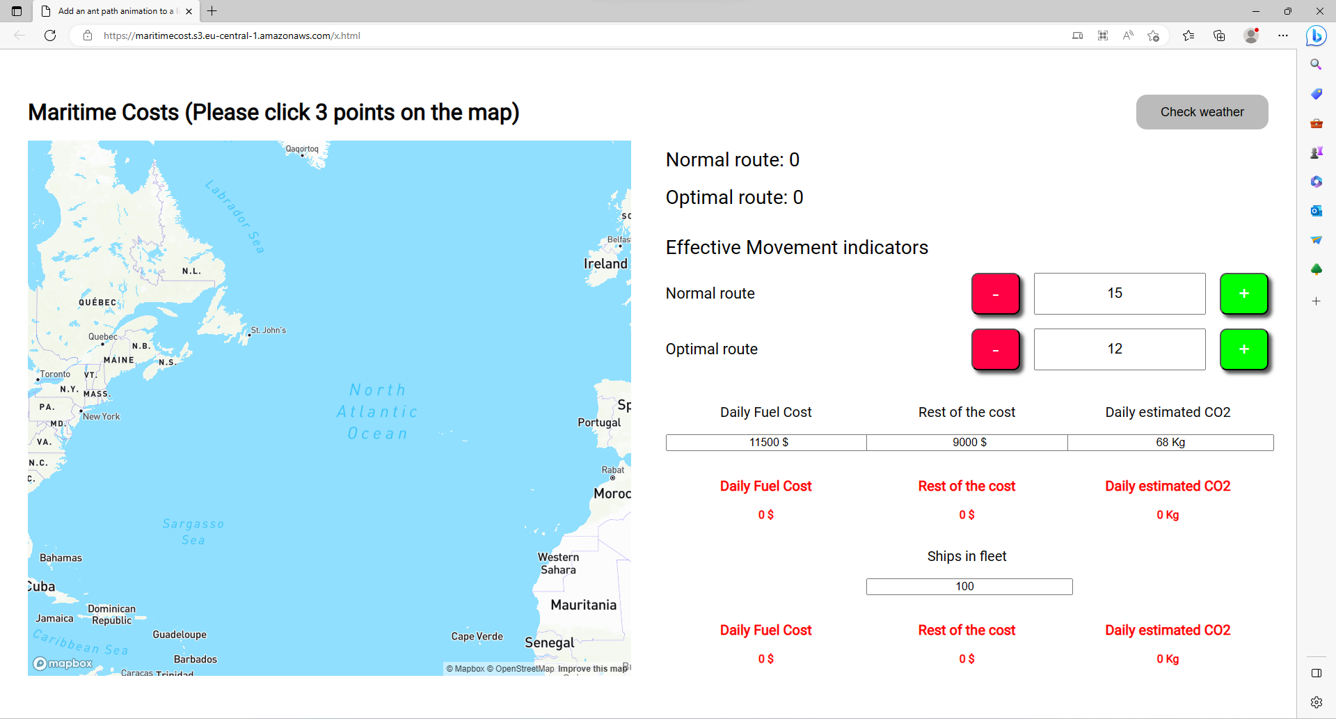
Our application was designed to assist ship navigators in optimizing their ship's course, thus cutting fuel consumption and time spent at sea. Its primary feature is its capability to calculate the difference between actual ship's course and the most optimal one.
❓How
To accurately predict a ship's course, we will be using real-time data from various sources such as satellites, weather forecasts, ocean currents and vessel traffic to calculate its actual course. We will then utilize historical data and advanced algorithms to calculate the most optimal course, taking into account factors such as fuel efficiency, shortest distance, and sea conditions. The application will feature an intuitive user-interface that enables ship navigators to input their current position, destination and vessel specifications; then they can view the actual course, most optimal course and any discrepancy between them. We will also send real-time alerts and notifications when adjustments need to be made in order to stay on target.
🚢 For who
Our application will be beneficial to shipowners by helping them cut fuel consumption and, thus, lower costs and emissions. By providing navigators with accurate and up-to-date data, we hope to enable them in making informed decisions and optimizing their ship's course for maximum success.
Our application provides benefits not only to navigators and shipowners, but also the insurance industry. By providing accurate information on a vessel's course and reducing accidents or damage to it or its cargo, insurers can make more informed decisions about insurance costs for a vessel. With real-time data and advanced algorithms, insurers can assess risk profiles more precisely and adjust premiums accordingly - decreasing under- or overinsurance risks. This not only benefits insurers by improving their risk management practices but also benefits shipping industries by offering more affordable yet appropriate coverage options.
In addition to cutting costs and emissions, MaritimeCost can also help ships extend their operational range. By optimizing a ship's course and decreasing fuel consumption, our application helps extend how long a vessel can operate before needing refueling - particularly important on long-distance or transoceanic voyages where being able to travel further without stopping can significantly improve efficiency and profitability.
🌱 Environment impact
Optimizing a ship's course can reduce fuel consumption and emissions, thus decreasing its carbon footprint. Not only will this be beneficial to the environment but it also assists companies in meeting international regulations and achieving their sustainability targets.
🛟 Safety
By giving navigators the most optimal course, our application can drastically enhance safety at sea. Utilizing real-time data and advanced algorithms, navigators are able to avoid potential hazards like rough seas, strong winds, or vessel traffic - thus reducing accidents and damage to either the ship or cargo. Furthermore, optimizing a ship's course and cutting fuel consumption also extends its engine and other components' lifespans, cutting maintenance costs and eliminating mechanical failure risks. In conclusion, our application makes shipping safer, more efficient, and sustainable - benefitting not only industry stakeholders but society at large through benefits such as benefits to society itself!
🛰️ EU space technologies
Our application will utilize satellite technology to provide accurate and up-to-date information. Satellites collect real-time data on weather conditions, ocean currents, vessel traffic, and other relevant factors that may influence a ship's course. Our application will transmit the collected data in real-time, giving navigators access to the most up-to-date information. Furthermore, our application will utilize historical data to create predictive models that can anticipate changes in weather patterns or ocean currents, providing navigators with early warnings of potential hazards. With satellite technology, our application offers a comprehensive and dependable picture of conditions at sea, improving its accuracy and effectiveness during course optimization processes.
🤼 Team
Grzegorz Pisarczyk
Senior Software Developer / CEO
I'm a Qt C++/QML/QtWidgets/SQL developer. Currently, I work as an independent contractor. Passionate about lean management and team building.
Maciej Żuk
Front End Developer
Creative front-end developer with a strong passion for design, who combines their technical skills with a keen eye for aesthetics to build visually stunning and user-friendly websites and applications.
Mateusz Borucki
Data Science
Starting programmer with a passion for coding in many different languages like C++, JavaScript or Python and a drive to make it their future. He is excited to participate in this hackathon and continue to develop their skills.
Sebastian Ozimkowski
Software Engineer
I am software engineer devoting most of my time backend engineering and cloud computing. Besides coding I love cycling and gaming
https://maritimecost.s3.eu-central-1.amazonaws.com/x.html