Critical Sense
Provide real-time risk assessment for critical infrastructure
- 96 Raised
- 555 Views
- 1 Judges
Team
Tags
Categories
Gallery


Description
The problem is:
How to monitor EU critical infrastructure damage in a intelligent and feasible way?
The solution is:
CRiTICAL SENSE
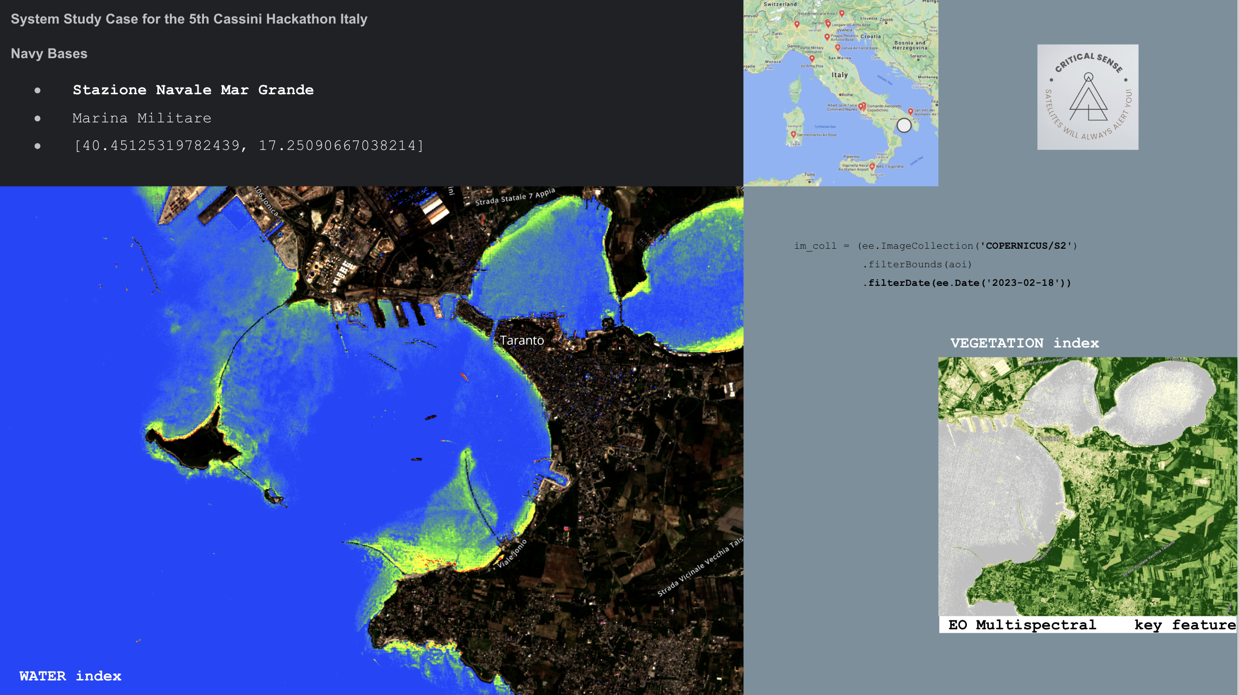
We use Satellites Space data to monitor Italy critical Infrastructure. In the 5th Cassini Hackathon We have focused satellites on:
- fire risk for high voltage lines and
- Stazione Navale Mar Grande.
🛰️ EU space technologies
We have used the next ESA Copernicus & Galileo Space Data:
- Sentinel 1 SAR data to detect objects in time and space.
- Sentinel-2 sensors guarantee free images in 13 multispectral bands: spatial resolution from 10 meters up to 60 meters. Sentinel 2 for the Normalized difference vegetation index
- EGNOS for drones Hi accuracy geolocation (future implementation).
🛰️ ITALY space technologies
PRISMA is a EO constellation with hyper-spectral optical sensor, capable of providing a unique information contribution for numerous applications, such as monitoring of environmental changes and pollution and supports the management of natural resources and emergencies.
This instrumentation consists of an imaging spectrometer capable of acquiring VNIR (Visible and Near-InfraRed) and SWIR (Short-Wave InfraRed) products, with a spatial resolution of 30 meters, and a panchromatic camera with a spatial resolution of 5 meters.
💻 Algorithms over EO & SAR data
- NDVI (Normalized Difference Vegetation Index): it describes the level of vigor of the crop and is calculated as the ratio between the difference and the sum of reflected radiation in the near infrared and in the red, i.e. as ( (NIR-RED)/(NIR+RED ) ).
- NBR index is one of the most widely used indexes for mapping burnt areas and for assessing fire severity as it is obtained from the ratio between the reflectances of the vegetation in the NIR (Near InfraRed) and in the SWIR (Short Wave InfraRed), the bands of the electromagnetic spectrum that are most affected by the change in vegetation following the passage of fire: the near infrared is strongly reflected by it, while SWIR provides significant information on its water content.
- Water Quality
- SAR reflectance in Descendent Orbit for changes in time ratio.
💪 Overview of the team members
We are a balanced team with strengths on space, finance, marketing and operations; a Cross-knowledge team focus on prior results, not titles.
Business & Marketing:
- Vittorio Emanuele Paolillo
- Vidas Pleta
Geologist:
- Annalisa Parisi
Aerospace Engineering
- Davide De Fano
- Jonatan Domènech
Artificial Intelligence and GIS
- Wenting Jiang
- Alessia Marchionna
💻 Link to:
NOTEs:
- JASON will be used for drones geolocation accuracy on PPK processor over GNSS raw data.
- MUNDI Notebook has been used for Sentinel 2 data, but the server was stoped with Hi Volume of Sentinel1 data.