- Hackathons
- Builders
- Organizations
- Learn
Green Travel Spots
GTS is developing a pollution benchmark to help public services and tourism platforms to accurately gauge the level of pollution in bathing waters and atmosphere at a given location, based in EO
- 65,133 Raised
- 30 Views
- 2 Judges
Tags
Categories
Gallery
Description
💎 Idea
Problem is POLLUTION of the Oceans and Air. The EU Action Plan foresees 'Zero Pollution for Air, Water and Soil' to be reached by 2030, reducing:
- 55% the health impacts of air pollution
- 50% plastic litter at sea
However, TODAY Public entities have a lack of data and accurate information about pollution to create policies in order to achieve EU’s Goal
How can we accurately measure the quality of air and water to allow a fast response from public municipalities, especially considering a fast increase in the number of tourists along seaside?
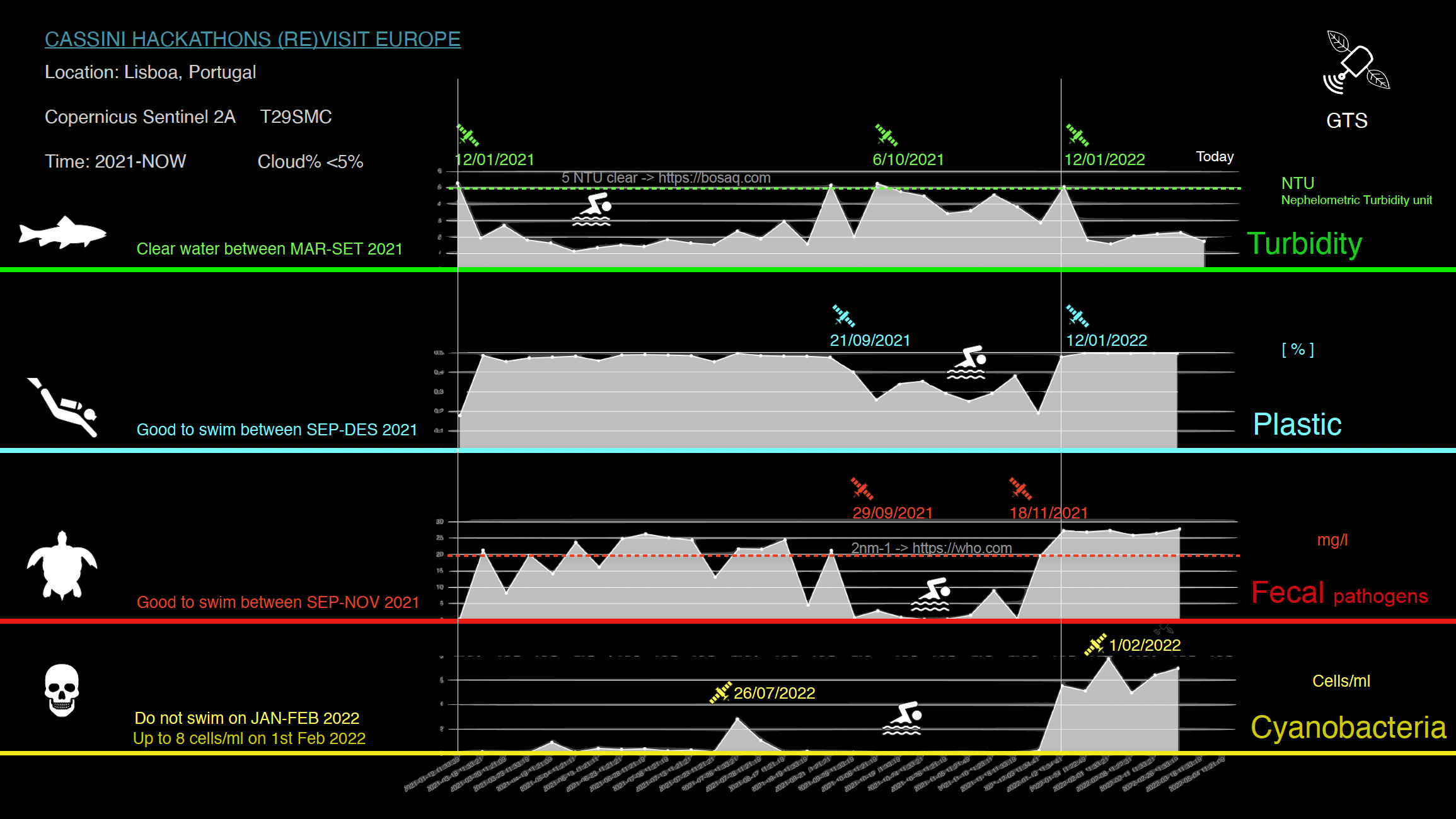
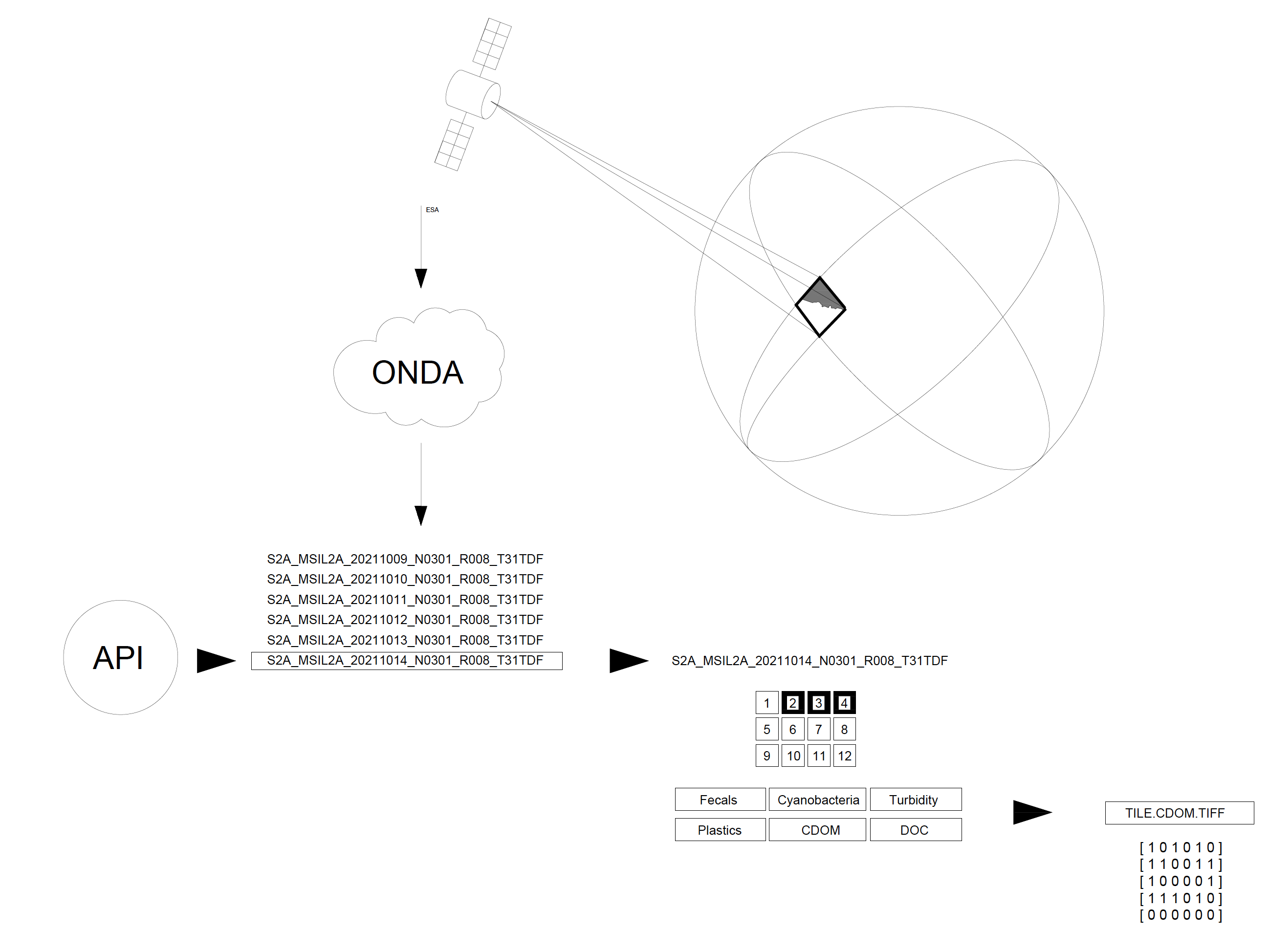
Solution is GTS tech, an API-based service that provides quality measurements and reports about water and air quality for any location in the world and in any date (since available satellites data of Sentinel or LandSat). GTS will deploy a pollution benchmark to help public services and tourism platforms to accurately gauge the level of pollution in the ocean, rivers and atmosphere at a given coordinate by designing an also that retrieves information from different sources, namely with local and space readings.
- European Municipalities will be able to evaluate tourism impact in the water and air quality.
- Public Agents will have quality information to plan and implement environmental policies
- Also aiming at the final customer, we plan to make this information also available in tourist sites such as Tripadvisor, who will be able to filter and rank holidays hotels and destinations by pollution level.
🛰️ EU space technologies
GTS deep analyse Copernicus Satellites EO Data and compute scientific papers indicators and water quality indices over spectrum bandwidths and improve the algorithms recalibrating them according to in situ ground stations data via Machine Learning:
Hackathon stage:
- S2 provides 60,20,10m accuracy data with 12 bandwidths to detect water bodies indicators.
- S3 is 300m accuracy daily data. BarcelonasCup tech has improved S3 to be S2 accuracy via deep learning in S2&S3 match days.
Next stage:
- S1 SAR provides data of the water wave shape and the wave is related to density, then it can detect oil spills.
- S5 provides PM2.5 and PM10 air quality indicators.
- Landsat Modis
- Maxxar
🏖️ (Re)Visit Europe
GTS solution will improve the development of sustainable tourist destinations, municipalities will be able to evaluate the environmental impact of tourism and deploy policies, while tourists will also be able to choose a destination according to sustainable ranking, not only price and stars.
💪 Team
Jonatan Domènech from Barcelona Spain, Architect and Aerospace engineer, focused on deep learning applied to satellite images to make a better world.
Gustavo Dalmarco from Porto, Portugal, Innovation Manager and Business Developer with experience with space entrepreneurship and innovation.
Fernando Bebiano Correia from Lisbon, Portugal, is an innovative Business Manager, with experience in tourism tech entrepreneurship.